Cima della Sueur   33640
previous panorama
next panorama
Orientation on / offOrientation on / off
Details / LabelsDetails / Labels Markers on / offMarkers on / off Overview on / offOverview on / off   
 Cycle through labels:   first previous stop
play
pause
next last
  zoom out
 

Labels

1 Grand Pic de Rochebrune
2 Vallée de la Clarée
3 Ancien fort de l'Olive
4 Roche Gauthier
5 Mont Pelvoux
6 Barre des Ecrins
7 Grande Ruine 3765m
8 Pic Gaspard 3883m
9 la Meije
10 Névache
11 Queyrellin 2936m
12 Tête de la Cassille 3069m
13 Grand Galibier
14 Crête de la Gardiole 2955m
15 Mont Thabor 3178m
16 Aiguille de Scolette
17 Pointe Sommeiller
18 Vallon des Acles
19 Rocher des Prés 2888m
20 Pointe des Grands Becs 3042m
21 Pointe des Rochers Charniers 3056m
22 Chaberton 3131m
23 Pointe de Pécé 2733m

Details

Location: Cima della Sueur - Sommet de Guiau (2657 m)      by: Andrea Rolando
Area: Cottische Alpen      Date: 16/01/2012
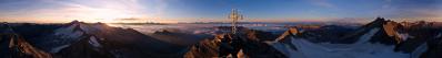
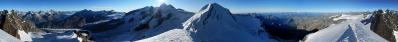
Cima della Sueur (which is referred to as Sommet de Guiau in the French maps) is a rocky and detritic mountain standing on the border between France and the westernmost point of Italy. It divides the charming Val Clarèe on the French side from the large hollow where lies the well known Bardonecchia ski resort on the italian side (east).
Due to its outstanding position, this summit offers a unique panorama on the whole region, including the highest summits in the Ecrins mountain range.

I will add labels as soon as possible!

Comments

Bellissima!
2012/01/16 18:01 , Stefano Caldera
Bello!
Aspettiamo le labels!
2012/01/17 14:14 , Marco Nipoti
I was there a long times ago. I have added some names at this very good Pano.
David
2012/10/26 19:43 , David Schatzman

Leave a comment


Andrea Rolando

More panoramas

... in the vicinity  
... in the top 100